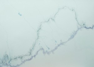
Here are some drawings about walking, water, and the Continental Divide. So far there are 30 of them and they cover my route for about 800 miles across Montana and the Idaho border.
I’ll get the technical aspects of these drawings out of the way first. Using maps (put together by Jonathan Ley) that showed where the Continental Divide is and where my route ought to have gone, as well as my recollections of where I actually walked (I will admit that sometimes I had only a vague idea of where I actually was), I drew out where I walked (in graphite) and the designation of the Divide (in purple) with the topographic lines closest to each. Water sources that I drank from are shown in blue. The only water shown is what affected me or that I affected, so where the water came from and then where it went after I gathered it. All drawings are on 18×24 sheets of paper.
Walking for me is experiencing distance and time at the speed of slow thought, of daydreams. Moving through the landscape for months on end, often alone, gives abundant time for thinking and it’s a wonderful time for thinking about art. And various peculiarities of life. And connections. And the mundane but very important questions of where to camp (actually, where am I right now??), what I have available to snack on and… where is my water? When I thought about water and art at the same time I also had to think about topography; the land telling the water where to go and the water shaping the land. I knew that the data I was gathering had to be represented in a way that considered the water’s path, my path, and the shape of the land, as well as all the time and space available for thought and daydreams. In drawing it out I got to experience the landscape again at a human pace, only this time by pencil rather than on foot. Meaning and memories became encoded in the topographic lines, and I became aware of another sense of space while watching the water flow across the paper from and to places that I couldn’t see and didn’t know. Maps show land all at once, as though viewed from the sky- something impossible to see while standing on the ground. Traveling through on foot one gains an intimate knowledge of what is immediately around with a vast expanse of unknown spreading out in all directions.
There are other thoughts to have on water: how it connects us to the land and to each other, how to conserve it, thoughts of dangerous water, thoughts about weather patterns… I could think on and on about water, but I think I’ll stop here for now.
Thanks to Valentin Florescu for photographing these drawings for me.